Those of you who know me know that I am an avid Vadder (urban) and Rudder (rural). I will practice either or both whenever I get the opportunity.
Today, after their homeschooling, my daughters and I took a sort of mini-Rudding expedition to the Falls Along the Cedars.
The Falls are part of a river way system which includes the remains of an old textile mill, the remains of (but still functioning) dam on that river, and the monumental remains of some of the old river construction and what is left of the surrounding industrial complex.
Being an amateur industrial archaeologist myself these remains are of double interest to me, triple really. Because not only is there rudding value in the remains, but I can often vad the mill complex and what is left of the old mill as well as make records of the industrial and textile complex that used to function there. The old mill is now little more than a storehouse, and a rotting one at that, for old textile and industrial machinery. But the plant goes back nearly a century in operation and in the surrounding ruins and countryside.
Below are some of the pictures I took today of the ruins. I thought many of you might enjoy these pictures of our rud and it might also give some of my international readers a look at some of the landscape in rural America. On Friday, which is the day we typically reserve for laboratory work and for field trips we plan on going back out to this area in full pack, appropriately dressed, and making a full fledged photographic expedition of the entire area. If we can we will also vad the old mill complex and take photographic evidence of the old industrial areas as well as trying to arrange a full scale industrial archaeology expedition with the current owners of the old mill. We'll also be hiking through the swamps along the river.
In addition on Friday I'll be taking my daughters on their first real "Bridging" expedition. Bridging is a form of rudding which might be thought of as equivalent to roofing when Vadding. In roofing you launch an expedition to the roofs of various buildings, any building you can access, hospitals, office buildings, libraries, hotels, theatres, malls, anything you can manage. Then you explore those roofs, move from roof to roof, climb the roofs, gain access to other areas, or whatever else you can manage to achieve during the expedition. Without being discovered or leaving any evidence of your passage, of course.
In bridging you launch expeditions to bridges, exploring those bridges from above, below, their construction, the surrounding land, the (often) secret/camouflaged/hidden but attached hideaways used by teenagers, drug and criminal gangs, individuals, and so forth. (You'd be surprised how often bridges are used as "dead drops" for various purposes.) I'll be going in broad daylight to bridges and areas I am already familiar with in order avoid any possible danger to my daughters. Although I will be taking them to a bridge under which was dumped the body of a man who had been murdered (one of the earlier string of river murder cases I worked in my late twenties) though that bridge is perfectly safe in daylight and well patrolled now.
In any case I'll be taking photographs of those expeditions on Friday and posting the results here as soon as I can process those images.
Now for today's mini-expedition.
Note: I downloaded 124 images from my camera. Obviously I'm not going to post all of those images to the Missal in this post. I'll only post a few of the more interesting shots here, though I may post more from this round later, in another post. I also wanted to mention that when it comes to my camera I am experimenting with different types of batteries, and currently I am using both different brands of lithium batteries and a new kind of battery called Titanium to provide power for my shots. I like both but the lithium batteries are far more powerful. The titanium provide good emergency back-up however. I've yet to experiment with either to see if my recharging equipment is capable of making either to accept a recharge.
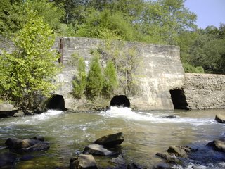
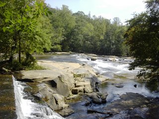
Dam Spillway - It is difficult to tell in this shot because of lack of perspective control but the dam itself is about 40 to 45 feet high from the bottom to the top of the utmost tier of the dam.
Second Tier, Left Bank - Shot taken from the top of the second tier of the length of the first tier and left bank.
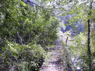
Pathway Back - This is the pathway back to the end of the dam and edge of the top tier, or the pathway I walked back along to get back to the bank and to land.

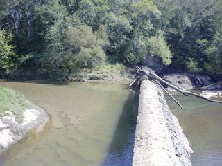
Pathway Out - Pathway leading from raised bank and hill out along the length of the top tier to the middle of the dam.
Dam Length - shot from atop a support structure on the right bank.
Three Spillways
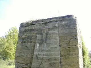
Outlying Support Pillar - One of the lonely outlying supports. These used to ring the river providing wall support for an encircling lower waterway and dam system. This system is now demolished and the connecting walls destroyed. About 15 feet high and this support was unclimbable without equipment.
Atop Support - The nest support. About a ten foot tall support I was able to climb (due to decay) from which I took some shots when atop it. You can see the top of a second dam wall being overspilled in the left side of the photograph.

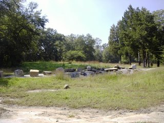
Construction Blocks - Blocks from the ruins have sometimes been carted away and set in the fields of local farmers.
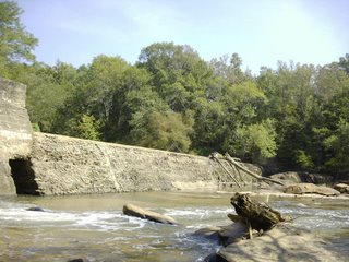
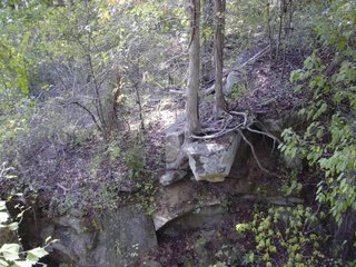
Remains of the Old Wall - This section of the old wall used to connect to the dam itself but has since fallen into decay and fallen apart. The wall used to rise about 30 to 35 feet form the river bank.


No comments:
Post a Comment